Riverside Regeneration Plan
The question
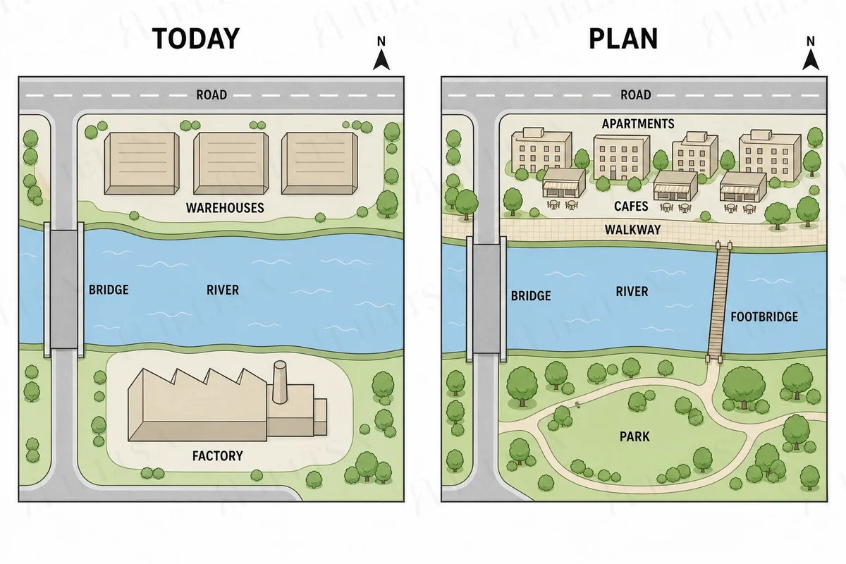
The maps below show a riverside area today and the plan for its redevelopment.
Summarise the information by selecting and reporting the main features, and make comparisons where relevant.
Write at least 150 words.
Instructions
You should spend about 20 minutes on this task.
• Begin with an overview of the main planned changes.
• Use future forms and location language such as to the east of and next to.
• Group the changes logically rather than describing every feature in turn.
• Do not give your own opinions.
How to approach this map question
A map question shows a place at two points in time (or two plans). Describe what changed, what stayed the same, and where, using direction and location language.
- Say what the maps show and the two time points in your own words.
- Overview: the main kind of change (for example more building, less green space) and one thing that stays.
- Describe changes area by area (north, south, centre) with verbs such as was replaced by, was converted into, was built.
- Use precise location phrases: to the east of, next to, opposite, in the north-west corner.
How to plan this answer
Structure
- Introduction: paraphrase the maps. The riverside area today and in the redevelopment plan.
- Overview: the north bank will be redeveloped into housing and leisure, the south-bank factory will become a park, and a footbridge will be added, while the road and bridge will remain.
- Body 1: the north bank, where the warehouses will become apartments and cafes with a walkway along the river.
- Body 2: the south bank, where the factory will be replaced by a park, and the new footbridge east of the road bridge.
Key features to spot
- The three warehouses on the north bank will be replaced by apartment blocks and cafes with outdoor tables.
- A walkway will run along the north bank beside the river.
- The factory on the south bank will be replaced by a park with paths and trees.
- A footbridge will be built to the east of the existing road bridge, linking the two banks.
- The road bridge, the river and the road along the top of the site will remain unchanged.
Useful vocabulary
- will be replaced by: The warehouses will be replaced by apartments and cafes.
- a walkway will run: A walkway will run along the river on the north bank.
- will be demolished: The factory will be demolished and the site turned into a park.
- to the east of: The footbridge will be to the east of the road bridge.
- on the north bank: The apartments will be on the north bank.
- will remain: The road bridge will remain in its current position.
- outdoor seating: The cafes will have outdoor seating along the walkway.
- linking: The footbridge will link the two sides of the river.
- the most significant change: The most significant change is the housing on the north bank.
- the south bank: The park will occupy the south bank.
Common mistakes
- Mixing up the north and south banks. The warehouses are on the north bank and the factory on the south bank.
- Calling the road bridge the footbridge. They are two separate features.
- Placing the footbridge to the west of the bridge. It is to the east.
- Saying the factory will remain. It will be replaced by a park.
- Describing the road as changed. It stays the same in the plan.
Examiner tip: Describe each bank separately, then the new footbridge, since linking the two banks is the feature that connects the two halves of the redevelopment plan.
Write your answer
Sign in with Google to write online and get 8 free answers marked each month against the IELTS band criteria. No card, no password.
Sign in with Google to writeMore practice questions
Practise all four IELTS skills
Listening, Reading, Writing and Speaking with band 8 samples at ieltsa.org.