Millbrook Village Over Thirty Years
The question
Instructions
How to approach this map question
A map question shows a place at two points in time (or two plans). Describe what changed, what stayed the same, and where, using direction and location language.
- Say what the maps show and the two time points in your own words.
- Overview: the main kind of change (for example more building, less green space) and one thing that stays.
- Describe changes area by area (north, south, centre) with verbs such as was replaced by, was converted into, was built.
- Use precise location phrases: to the east of, next to, opposite, in the north-west corner.
How to plan this answer
Structure
- Introduction: paraphrase the maps. The village of Millbrook in 1995 and 2025.
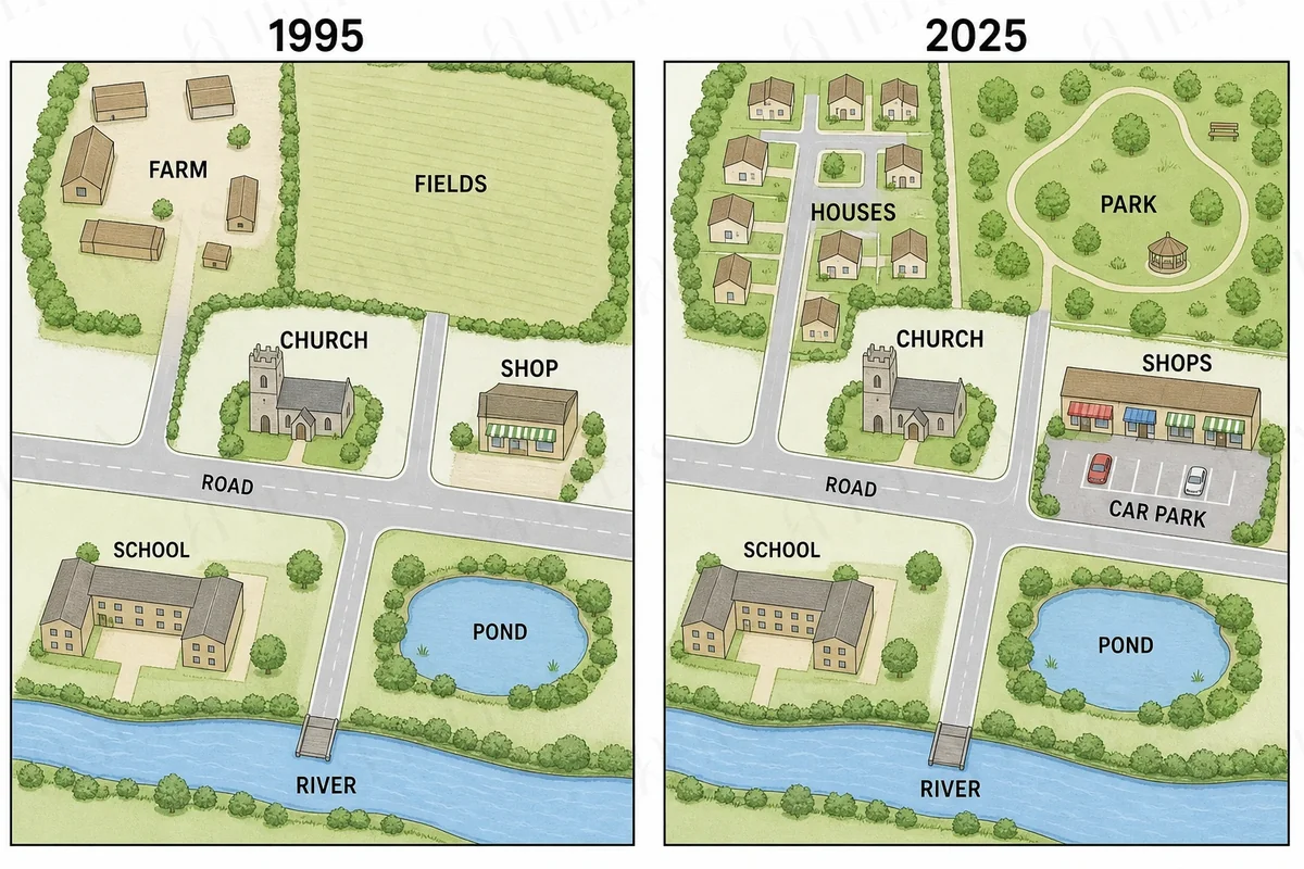
- Overview: the village changed mainly through new housing, a park and a larger shopping area, while the church, school, pond, river and main road stayed the same.
- Body 1: the north-west, where the farm was replaced by houses, and the north-east, where the fields became a park.
- Body 2: the central east, where the single shop became a row of shops with a car park, plus any other unchanged features.
Key features to spot
- The farm in the north-west, with several buildings, was replaced by a housing area with many small houses along new roads.
- The large field in the north-east became a park with a looping path, trees and a gazebo.
- The single shop beside the main road was replaced by a row of shops with a car park in front.
- The church, school, pond, river and main road remained unchanged, so the village core stayed the same.
- A new road now runs north through the housing area, which shows how the village expanded.
Useful vocabulary
- to the north-west of: The farm was located to the north-west of the church.
- was replaced by: The farm was replaced by a housing development.
- on the site of: The park now occupies the site of the former fields.
- a row of shops: The single shop was replaced by a row of shops.
- remained unchanged: The church and school remained unchanged over the thirty years.
- to the east of: The shops are situated to the east of the church.
- the most noticeable change: The most noticeable change is the new housing in the north-west.
- a looping path: The park has a looping path through the trees.
- is now home to: The north-west is now home to a cluster of houses.
- in place of: A car park was built in front of the shops in place of open ground.
Common mistakes
- Confusing north-west and north-east. The farm was in the north-west and the fields in the north-east.
- Describing the 1995 map in the present tense, such as there is a farm. Use the past tense for 1995.
- Describing every feature in turn. Group the changes into areas to create a logical comparison.
- Saying the shop is still a single building. In 2025 it has become a row of shops with a car park.
- Including the church or school as changed. They stayed the same, and mentioning them is useful only as a contrast.
Examiner tip: Name the changed areas by their position, such as north-west and north-east, and state clearly which features stayed the same, because the unchanged features make a useful point of comparison.
Model answers by band score
Written for this question to show what changes from one band to the next. Try the task yourself first, then compare.
Band 6 answer
Why this is band 6
- Identifies the three main changes (farm to houses, fields to park, shop to shops with a car park) and the unchanged features, all correct to the maps.
- Basic location language ('in the north-west', 'next to') and a limited range of vocabulary; the tense control slips ('is gone', 'was built' with 'is changed').
- Several visible errors ('The park have', 'more big', 'still be there') but meaning remains clear.
- Band 7 would use a consistent past tense, vary the language of change ('was replaced by', 'was converted into') and give more precise locations.
Band 7 answer
Why this is band 7
- Clear overview separating the developed north and east from the unchanged centre and south, and all details match the maps.
- Good range of change vocabulary ('replaced by', 'turned into', 'had been demolished') and accurate location language ('to the east of the church').
- Information is grouped logically, but a few details are vague ('another significant change') and some sentences are long and slightly repetitive.
- Band 8 would use tighter, more varied phrasing and more precisely select features, such as the road layout, without listing.
Band 8 answer
Why this is band 8
- The overview is precise and groups the changes under residential, leisure and retail use rather than listing features.
- Language is flexible and exact ('had given way to', 'branched off', 'a longer parade of shops') with rare errors and natural linking.
- Locations are accurate throughout (north-west, north-east, east of the church, between the parade and the main road).
- Band 9 would be wholly seamless, with no loosely connected clauses and a more economical overview.
Band 9 answer
Why this is band 9
- The overview is exact and sophisticated ('the historic core... remained exactly as it had been') and organises the whole description.
- Every feature matches the maps (farm to housing with an extended access road, fields to park, shop to row of four shops with car park, constant church, school, pond, bridge).
- Vocabulary is accurate and natural ('superseded', 'landscaped into') with no errors and varied syntax.
- Cohesion is seamless, and the final paragraph neatly accounts for the unchanged features without needless repetition.
Band levels are our estimate against the public IELTS criteria; they are not official scores.
Write your answer
Sign in with Google to write online and get 8 free answers marked each month against the IELTS band criteria. No card, no password.
Sign in with Google to writeMore practice questions
Practise all four IELTS skills
Listening, Reading, Writing and Speaking with band 8 samples at ieltsa.org.